Remote sensing is a technology used for obtaining information about a target through the analysis of data acquired from the target at a distance. It is composed of three parts, the targets - objects or phenomena in an area; the data acquisition - through certain instruments; and the data analysis - again by some devices. This definition is so broad that the vision system of human eyes, sonar sounding of the sea floor, ultrasound and x-rays used in medical sciences, laser probing of atmospheric particles, are all included. The target can be as big as the earth, the moon and other planets, or as small as biological cells that can only be seen through microscopes. It is a technology enabling us to observe an object�s size, shape and character without direct contact with it. The reason why they can be observed without contact results from the characteristics of electromagnetic waves, such as light reflected or radiated from the objects. Sensors aboard earth observation satellites receive these reflected or radiated electromagnetic waves.
|
|
||
|
|
�Observing the earth by satellite. |
|
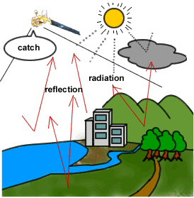
In general, the characteristics of reflected or radiated electromagnetic waves depend on the type or condition of the objects. Therefore by understanding the characteristics of electromagnetic waves and by comparing them to the observed information, we can know the size, shape and character of the objects.
Source:� www.eoc.nasda.go.jp/experience/rm_kiso/whats_remosen_e.html
Every material on earth shows its own strength of reflection in each
wavelength when it is exposed to the electromagnetic waves (visible light and
invisible light, such as infrared rays, ultraviolet rays or electric waves).
Also, when the material gets hot, it radiates showing its own strength in each
wavelength.
The figure below shows the strength of reflection and radiation from plants,
earth and water in each wavelength. The horizontal axis shows wavelength, left
side is shorter and right side is longer. According to wavelength, it is called
as ultraviolet ray, visible light, infrared ray, microwave, etc.
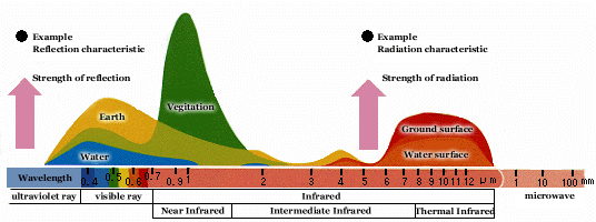
Strength of reflection and
radiation of electromagnetic
waves from plants, earth and water in each wavelength.
Also, the strength of reflection and radiation differs according to the condition of objects, such as type of plants, status (dead, weak, etc.) or contamination of water. For example, the figure below shows the difference of reflectance by the status of plant, from the top, leafy healthy plants, dry feeble plants, and dead plants.
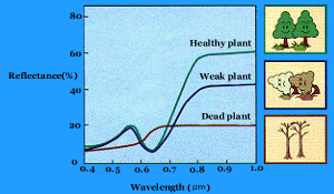
Difference of reflectance according to the
condition of plants
Source: www.eoc.nasda.go.jp/experience/rm_kiso/mecha_howto_e.html
http://rst.gsfc.nasa.gov/start.html�� What you can learn from sensors on spacecraft that look inward at the earth and outward at the planets, the galaxies and, going back in time, the cosmos.
http://seaspace.esa.int:8000/exercises/default/� A good introduction to remote sensing. This series of slides offers a very brief introduction to the physics of Remote Sensing and building a digital image. They can be viewed online, or printed and used as viewgraphs.
Source: www.cnr.berkeley.edu/~gong/textbook/�� From a course at
the
www.the-rss.org/�� The Remote Sensing and Photogrammetry Society.
www.nohrsc.nws.gov/experimental_products/snow_model/�
www.ccrs.nrcan.gc.ca/ccrs/imgserv/tour/toure.html�� Tour
http://fermi.jhuapl.edu/��
www.geo.mtu.edu/rs/��